Manaslu Circuit Alternative Route

ratingbased on 4 reviews
  • Duration20 Days
  • Difficulty Level Strenuous
  • Activity Trekking/Hiking
  • Max. Altitude 5106 meters/ 16752 feet
  • Starts Baseri
  • Ends Kathmandu or Pokhara
  • Group Size 1-12 People
  • Best Season March to May & September to November
Group Discount Prices
  
2 - 3 paxUS$1245
4 - 6 paxUS$1090
7 - 12 paxUS$1045
Manaslu Circuit Alternative Route Highlights
  • Take the Manaslu Circuit Alternative Route from Kathmandu through Baseri, following a quieter trail away from the hot, dusty, and vehicle-heavy regular road.
  • Experience the Baseri to Kashigaun to Kerauja section, which is a less-traveled route through lush forests, waterfalls, hill villages, and dramatic Himalayan landscapes.
  • Spend your first trekking night in a local homestay in Baseri.
  • Enjoy panoramic views of Sringi Himal, Ganesh Himal, and Buddha Himal from the hills around Baseri and Kashigaun.
  • Walk through peaceful forests filled with rhododendron, subtropical vegetation, waterfalls, and mountain streams on the alternative trail.
  • Pass through the traditional settlements of Gurung and other Himalayan communities.
  • Pass the Tsum Valley and Larkya La trail junction near Philim before continuing northwest toward Deng and the upper Budhi Gandaki Valley.
  • Trek through increasingly dramatic river gorges, pine and fir forests, waterfalls, and high mountain terrain as the Manaslu Circuit trail climbs toward Bihi Phedi and Namrung.
  • See Sringi Himal, Ganesh Himal, Kutang Himal, and surrounding peaks as the valley opens toward the higher Himalayan region.
  • Explore Prok village, a traditional mountain settlement known for its scenic position and views of the surrounding peaks.
  • Stay overnight in Shyala, one of the most scenic villages on the Manaslu Circuit, surrounded by an almost uninterrupted panorama of snow-covered Himalayan peaks.
  • Visit Pungen Gompa, one of the journey’s major side hikes and viewpoints, with sweeping views of Manaslu, Himal Chuli, Ngadi Peak, Kutang Himal, glaciers, and surrounding valleys.
  • Hike toward Birendra Lake at around 3,700 meters, a glacial lake beneath the dramatic mountain walls of the Manaslu region.
  • Take the more demanding Manaslu Base Camp hike, reaching around 4,980 meters for closer views of Mount Manaslu, glaciers, and the surrounding high-altitude landscape.
  • Observe the changing Himalayan flora and wildlife at higher elevations, where blue sheep, Himalayan birds, marmots, and other high-altitude species may be encountered depending on season and conditions.
  • Spend a second acclimatization day in Samdo with the optional Rui La border hike.
  • Enjoy expansive views toward the Tibetan frontier, Fukang Glacier, and surrounding Himalayan peaks from the Rui La trail.
  • Cross Larkya La Pass at 5,106 meters, the highest point of the Manaslu Circuit Trek.
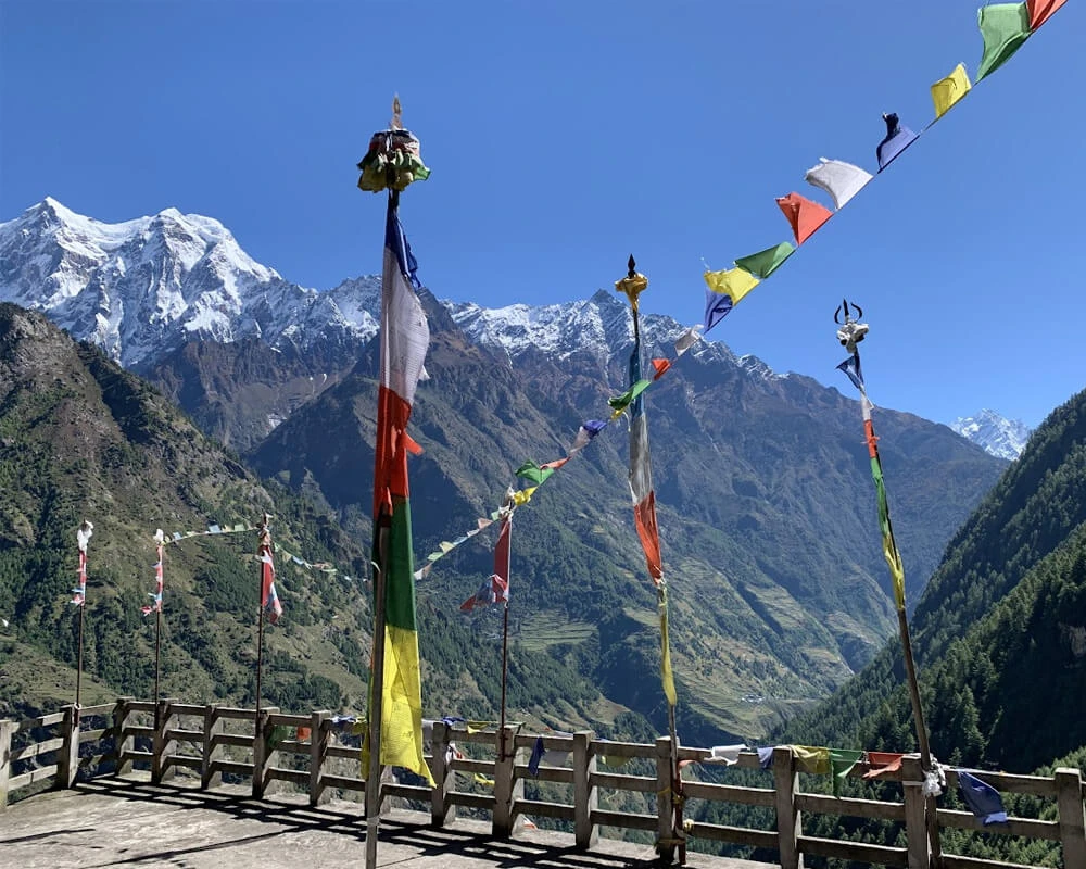
  • Stand beneath the prayer flags at Larkya La Pass and take in panoramic views of the surrounding Himalayan ranges after completing the crossing.
  • Enjoy views of Manaslu on one side and the Annapurna range on the other during the descent toward Bhimthang.
  • Relax in Pokhara after the end of your journey.

Manaslu Circuit Alternative Route Overview

The Manaslu Circuit Alternative Route offers a quieter way into the Manaslu region, beginning with a scenic drive from Kathmandu to Baseri Village in Gorkha District rather than following the usual lower Manaslu approach. From Baseri, the trail climbs through Kashigaun, Yarsa, and Kerauja before descending toward Dovan, where it connects with the established Manaslu Circuit route. From there, the journey continues through Philim, Namrung, Lho, Shyala, Samagaun, Samdo, and Dharamsala before crossing Larkya La Pass at 5,106 meters and descending through Bhimthang and Goa to Dharapani.

This alternative Manaslu route is designed if you want more than the standard road approach. The opening section takes you through quiet mountain villages, forested trails, waterfalls, terraced farmland, and a landscape that sees far fewer trekkers than the established lower circuit. Baseri itself sits on a hillside with views toward Sringi Himal, Ganesh Himal, and Buddha Himal, while the trail toward Kashigaun and Kerauja gives you an early taste of the rural Himalayan environment before the high mountains fully come into view.

One of the defining features of this alternative route is its connection with local village life. Instead of beginning the trek among the road corridors and busier settlements of the conventional approach, you spend the first nights around remote communities where farming, livestock, traditional houses, local food, and everyday village routines remain part of the experience. A homestay in the lower section makes this especially personal, giving you an opportunity to interact with local families and experience rural Nepal beyond the usual teahouse setting.

From Baseri to Kashigaun and Kerauja, the trail moves through lush forests and peaceful hillsides, with waterfalls and mountain views appearing along the way. This section also provides a gradual introduction to trekking at altitude before the route joins the main Manaslu corridor at Dovan. Once on the established trail, the scenery changes from lower-elevation forests and terraced hills to the dramatic Budhi Gandaki gorge.

The route then enters the heart of the Manaslu Conservation Area, passing through Philim, Bihi Phedi, Prok, and Namrung before reaching the upper Nubri Valley. Here, the landscape becomes increasingly alpine, while Buddhist traditions and Tibetan-influenced culture become more prominent. 

The upper section also leaves plenty of room for exploration beyond the main trail. From Samagaun, you can choose a side hike to Birendra Lake, Manaslu Base Camp, or Pungen Gompa, while the acclimatization stop at Samdo provides an opportunity to hike toward Rui La on the Tibetan border. 

The final mountain section takes you from Samdo to Dharamsala before the demanding early-morning crossing of Larkya La Pass. At 5,106 meters, the pass is the highest point of the trek and connects the Manaslu region with the landscapes around Bhimthang. After the crossing, the trail descends through alpine meadows, yak pastures, rhododendron forests, and greener valleys before reaching Goa and Dharapani. From Dharapani, the road connects onward toward Besisahar, with the option to continue to Kathmandu or Pokhara.

In short, it combines a remote village approach with the classic high-altitude Manaslu experience. If you have additional time, the Tsum Valley Trek can also be incorporated for a deeper experience of the region's Tibetan Buddhist culture and remote Himalayan villages.

Why Choose The Manaslu Circuit Alternative Route Instead Of The Classic Manaslu Route?

The main reason to choose the Manaslu Circuit Alternative Route is simple: the alternative approach is intended to avoid much of the road-dominated lower section of the classic approach, replacing the early road corridor with village trails, forests, ridges, and rural landscapes. 

Instead of beginning with the busier lower Manaslu corridor, you start among smaller villages and less-frequented trails. This gives the first few trekking days a distinctly peaceful character before you meet the main circuit at Dovan. Similarly, the lower alternative trail already offers views toward Ganesh Himal, Buddha Himal, and Sringi Himal.

The alternative route also adds accommodation with local families in an area where conventional tea house infrastructure is limited. That means your introduction to Manaslu is based more on village hospitality and everyday life than on a typical trekking lodge experience.

While walking through Baseri, Kashigaun, Yarsa, and Kerauja, you get to see farming, livestock, traditional homes, local customs, and village routines before entering the more established trekking settlements farther north.

Above all, choosing the alternative route does not mean missing the main attractions. You still experience Philim, Namrung, Lho, Shyala, Samagaun, Samdo, Dharamsala, Larkya La, Bhimthang, and Dharapani, along with the major side hikes available on the itinerary. If your priority is to combine the Manaslu Circuit Trek with authentic village experiences, the alternative approach adds cultural depth. Lastly, it also works well if you want to build a longer itinerary.

What To Expect On The Manaslu Circuit Alternative Route?

Walk Through Remote Villages And Experience Local Himalayan Culture

One of the most rewarding parts of the Manaslu Circuit Alternative Route is the chance to experience village life before the trail reaches the high Himalayan settlements. The journey begins around Baseri, then passes through Yarsa, Kashigaun, and Kerauja, giving you a glimpse of everyday life in rural Gorkha.

Baseri is situated on a scenic hillside with views toward Ganesh Himal, Sringi Himal, and Buddha Himal. Life here remains closely connected to the land, with farming, livestock, and household work forming. Staying in a local homestay gives you a more personal introduction to the region.

The trail continues through Yarsa and Kashigaun. As you walk toward Kerauja, the villages become quieter and more isolated. Local residents are largely from indigenous hill communities, including Gurung communities, whose language, customs, food, dress, and oral traditions form an important part of the cultural landscape.

Further along the route, the character of the villages gradually changes as you enter the Budhi Gandaki Valley. At Philim, Gurung culture remains particularly visible. From here, the trail continues toward Namrung, Lho, Shyala, Samagaun, and Samdo, where the culture becomes increasingly influenced by the Tibetan Buddhist traditions of the high Himalayas

In the upper Manaslu region, Tibetan Buddhism plays a central role in community life. You see Buddhist monasteries, chortens, mani walls, prayer wheels, and colorful prayer flags along the trail, while the architecture changes to suit the colder mountain environment. Villages such as Lho and Samagaun retain strong Buddhist traditions.

The people of the upper Nubri Valley traditionally rely on a combination of agriculture, livestock, and trade, with barley, potatoes, buckwheat, and other crops adapted to the short growing season. Yaks and other livestock remain important at higher elevations, providing food, transport, wool, and other necessities. In Samdo, close to the Tibetan border, the influence of Tibetan culture becomes even more apparent in the language, architecture, dress, food, and Buddhist traditions.

Now, festivals also bring these communities together and reflect the region's strong Buddhist heritage. Lhosar, particularly Tamu Lhosar among Gurung communities, marks the Tibetan New Year period with family gatherings, traditional food, music, dancing, and cultural celebrations. 

In the upper Buddhist villages, festivals and religious occasions associated with the Tibetan Buddhist calendar bring communities together at monasteries and village gathering places. Mani Rimdu, although most famously associated with the Sherpa communities of the Everest region, is part of the broader Himalayan Buddhist festival tradition. Here, local celebrations and monastery rituals in Manaslu vary from village to village.

Overall, the alternative route begins among the farming communities and homestays of the lower hills, moves through Gurung settlements and the deep Budhi Gandaki Valley, and eventually reaches the Tibetan-influenced Buddhist villages of the upper Manaslu region. 

Cross Larkya La Pass At 5,106 Meters

Crossing Larkya La Pass at 5,106 meters / 16,752 feet is the defining high-altitude experience of the journey. The pass forms the high point of the trek, linking the upper Manaslu valley with the Bhimthang side of the circuit. After days of gradually gaining altitude through Samagaun, Samdo, and Dharamsala, the trail finally leaves the settled valleys behind and climbs into a stark world of rocky slopes, snow, glaciers, and wide-open mountain terrain.

The Larkya La crossing begins early from Dharamsala, usually before sunrise. The first part of the walk takes place in the cold and darkness, with headlamps lighting the trail as you slowly gain height. The air becomes noticeably thinner, the landscape more barren, and every uphill step demands patience. The trail is not a technical mountaineering route, but the combination of high altitude, cold, steep sections, changing weather, and a long descent makes this one of the most demanding days.

As daylight reaches the mountains, the surroundings begin to open up. The lower forests and villages are long behind you, replaced by glacial valleys, rocky moraines, snow-covered slopes, frozen sections, and broad Himalayan ridges. Depending on the season and conditions, the trail can be covered with snow or ice, while strong winds can make the exposed pass feel considerably colder than the lower valleys.

The final climb is a steady series of switchbacks. You keep moving toward the ridge, then the familiar sight of prayer flags marking Larkya La finally comes into view. Standing at 5,106 meters, you are surrounded by an extraordinary high-Himalayan panorama. 

On a clear day, the views extend toward Himlung Himal, Cheo Himal, Gyaji Kang, Kang Guru, and Annapurna II, with the rugged peaks and glaciers spreading across the horizon. The wide, exposed setting of the pass makes the mountains feel particularly immense.

There is also a powerful sense of contrast from the top. Behind you lies the rugged landscape of the Manaslu region and the Budhi Gandaki Valley that you have spent days walking through. Ahead, the terrain drops toward Bhimthang and the Dudh Khola Valley, eventually becoming greener and more forested. 

From the pass, the trail drops through rocky and sometimes snow-covered terrain before gradually opening toward the Bhimthang Valley. The scenery becomes softer as the altitude decreases, with alpine meadows, glacial streams, and eventually greener vegetation replacing the stark surroundings of the pass. 

For many trekkers, the most memorable part of crossing Larkya La Pass is standing in a vast, almost silent mountain landscape after days of walking toward this point. You feel the altitude, the cold, the effort, and the scale of the Himalayas all at once. While at the top, you can take a natural moment to stop, catch your breath, look across the mountains, and appreciate just how far you have come.

Experience Changing Landscapes With Flora, Fauna, And Himalayan Wildlife

The trek begins among green hills, terraced farmland, waterfalls, and forested trails around Baseri, Kashigaun, and Kerauja, then follows the Budhi Gandaki Valley through increasingly rugged terrain before reaching the alpine world of Samagaun, Samdo, and Larkya La. The Manaslu Conservation Area itself stretches from around 600 meters to the 8,163-meter summit of Mount Manaslu.

In the lower section, the trail feels warm, green, and alive. You walk along terraced hillsides, narrow village paths, forest trails, riverbanks, and suspension bridges, with waterfalls and streams appearing along the way. Around Baseri and the alternative trail toward Kashigaun and Kerauja, the hills remain heavily vegetated, while distant views of Ganesh Himal, Sringi Himal, and Buddha Himal begin to introduce the Himalayan scenery ahead

As you continue toward Dovan and Philim, the trail enters the deeper Budhi Gandaki gorge. Steep cliffs rise above the river, forests surround the path, and the sound of flowing water accompanies much of the walk. The vegetation gradually changes as you climb, with subtropical woodland giving way to cooler mountain forests. Depending on the season, you can see rhododendron, pine, fir, juniper, and other Himalayan vegetation.

The scenery becomes increasingly dramatic around Namrung, Lho, and Shyala. Dense forests begin to thin, the valley opens wider, and snow-covered peaks become much more prominent. From Shyala in particular, the surrounding mountains seem to rise directly from the village, with Manaslu, Himal Chuli, Ngadi Chuli, and other peaks dominating the horizon. 

Beyond Samagaun, the landscape becomes distinctly alpine. Birendra Lake, Manaslu Base Camp, glaciers, yak pastures, and barren mountain slopes replace the greener valleys below. At Samdo, the surroundings become even more stark, with sparse vegetation, exposed rock, and wide views toward the high mountains and Tibetan borderlands. By the time you approach Dharamsala and Larkya La, the landscape is largely shaped by altitude, snow, ice, rock, and glacial terrain.

This dramatic ecological change also makes the Manaslu Circuit a rewarding wildlife and birdwatching trek. The Manaslu Conservation Area is home to more than 2,000 plant species, 39 mammals, 201 bird species, three reptiles, and 11 butterflies.

Now, wildlife sightings are never guaranteed, but the region provides habitat for animals such as blue sheep, Himalayan tahr, Himalayan serow, Himalayan marmot, musk deer, red fox, lynx, and the elusive snow leopard. In the higher and more open sections, you may also get opportunities to spot Himalayan birds such as the Himalayan griffon, golden eagle, Tibetan snowcock, snow partridge, and chukor partridge.

You may not encounter the region's most elusive animals, but even smaller signs of wildlife make the trail feel wonderfully wild. The flora and fauna become part of the trekking experience in much the same way the mountains do. 

Watch The Himalayas Change From Manaslu To Annapurna

One of the best parts of this route is that the mountains do not look the same from start to finish. They slowly grow from distant shapes behind green hills into massive walls of rock and snow, then change again as you cross Larkya La and descend toward the Annapurna region. 

In the early Baseri and Kashigaun section, the mountains are still part of the wider landscape. You walk through green hills, terraces, forests, and villages, occasionally catching a clear Himalayan peak between ridgelines. From the higher viewpoints around Baseri, you get to witness Sringi Himal, Ganesh Himal, and Buddha Himal.

As the trail moves through Kerauja and toward Dovan, the landscape becomes deeper and more dramatic. The Budhi Gandaki Valley cuts through steep hills, and the surrounding ridges make the mountains appear, disappear, and reappear from different angles. 

Once you reach Namrung, Lho, and Shyala, the scale changes noticeably. Manaslu becomes the dominant presence, joined by peaks such as Himal Chuli and Ngadi Chuli. At Shyala, the valley opens much wider, so you can stand surrounded by high mountains.

From Samagaun to Samdo, the scenery becomes distinctly high Himalayan. This is where you get some of the most memorable perspectives of Manaslu and the surrounding Himalayan peaks. At this altitude, the experience is also strongly influenced by the time of day. 

Early morning is often the most rewarding period for clear mountain views, when the air can feel crisp, and the peaks stand sharply against the sky. By late morning, clouds can begin building around the mountains, sometimes softening or hiding the peaks. Afternoon light gives the landscape a warmer, more dramatic appearance when visibility remains good. 

The approach to Larkya La Pass strips the landscape down even further. The mountains now feel more like an enormous natural amphitheater. You leave the familiar views around Manaslu behind and cross into a stark high-altitude landscape.

Later, the descent from Bhimthang toward Goa and Dharapani brings a surprisingly quick return of greenery. Manaslu gradually feels farther away, while the Himalayan scenery begins to connect with the Annapurna side of the country.

This transition is one of the most satisfying parts of the Manaslu Circuit. By the time you reach Dharapani and continue toward Besisahar, the mountains are no longer as close and enclosed.

If your journey continues to Pokhara, the Himalayan experience changes one final time. From here, you see them from a distance across the valley, lake, and surrounding hills. Here, Machhapuchhre (Fishtail) becomes one of the most recognizable peaks on the skyline, while the wider Annapurna massif forms the dramatic backdrop. You may even see Dhaulagiri and Manaslu farther away from suitable viewpoints.

Side Trips And Extra Adventures On The Manaslu Circuit Alternative Route

Hike To Birendra Lake For Glacial Views Beneath Manaslu

Birendra Lake, or Birendra Tal, is a high-altitude glacial lake near Samagaun, situated at roughly 3,600 to 3,700 meters in the Manaslu Conservation Area. Fed by the glaciers around Mount Manaslu, the lake sits in a rugged basin surrounded by moraine, rocky slopes, ice, and some of the highest peaks in the region. It is one of the most popular side trips on the Manaslu Circuit Trek because it takes only a few hours from Samagaun and gives you a completely different perspective of the mountain landscape.

The walk begins from Samagaun, which is one of the main acclimatization villages on the Manaslu Circuit. You leave most of your gear at the teahouse and head out with a small daypack. The trail climbs gradually above the village before becoming more rocky and uneven as it approaches the lake. Depending on your pace and the trail conditions, the hike commonly takes around one to two hours each way.

The scenery changes surprisingly quickly once you leave Samagaun. The village, fields, and scattered houses gradually fall behind as the trail enters a much more open alpine environment. You pass through rocky ground, sparse vegetation, and moraine terrain, with Manaslu and its surrounding glaciers becoming increasingly prominent.

There is no complicated technical climbing involved, but the altitude makes the short distance feel more demanding than it would at lower elevations. The final sections can involve loose stones and uneven ground, so a slow and steady pace makes the walk much more enjoyable.

As you climb higher, the landscape becomes quieter. The familiar green hills of the lower Manaslu Circuit disappear, replaced by barren slopes, glacial debris, snow-covered ridges, and enormous mountain walls. It is one of those short Himalayan hikes where the scenery changes much faster than the distance suggests.

The lake itself is a glacial lake formed in a moraine-dammed basin and fed by meltwater from the Manaslu Glacier system. This lake is surrounded by the Manaslu, Pungyen, Thulagi, and Ponkar glacier systems.

On a clear day, the water can appear strikingly blue or turquoise against the grey moraine and white mountain slopes. When the surface is calm, the surrounding peaks can reflect across the lake, giving it a mirror-like appearance.

Standing beside it gives you a much better sense of how different the environment is at this altitude. You can see glacial debris, steep rocky slopes, ice-covered terrain, and the enormous mass of Manaslu rising above the surrounding landscape.

Birendra Lake is commonly visited during the acclimatization day in Samagaun. This fits naturally with the “climb high, sleep low” approach commonly used while acclimatizing at altitude. The experience feels very different from the villages lower on the Manaslu Circuit. 

While here, you can enjoy the scenery, photograph the lake and mountains, rest by the shoreline, and experience the glacial landscape before returning to Samagaun. If the weather is clear and the trail conditions are suitable, the surrounding moraine areas also provide different angles for photography.

Early morning can be particularly beautiful because calmer conditions may create reflections on the lake. There are also no lodges or tea shops at the lake, so you must carry water, snacks, warm layers, and everything you need for the short outing.

A short fun fact: the lake is widely known as Birendra Tal, after the late King Birendra Bir Bikram Shah of Nepal.

Visit Pungyen Gompa Beneath The Manaslu Massif

High above Samagaun, the trail leaves the main Manaslu Circuit route and climbs into a quieter alpine landscape toward Pungyen Gompa, also written as Pungen Gompa or Pungyen Monastery. Situated at around 4,000 meters, the gompa is a Buddhist religious site associated with the Nubri community and one of the most meaningful cultural side trips on the Manaslu Circuit. It combines Himalayan scenery, living Tibetan Buddhist traditions, and a close perspective of the Manaslu massif in one outing.

Pungyen Gompa is a working spiritual place. The monastery is connected to local religious life, so the experience depends on when you visit and what is happening there on the day. You may see prayer flags moving in the cold mountain wind, prayer wheels, mani stones, butter lamps inside the monastery, or local people visiting for prayer and offerings. 

The side trip begins from Samagaun, which is one of the major villages in the upper Budhi Gandaki Valley. The trail gradually leaves the settlement behind. Stone houses become smaller in the distance, cultivated land gives way to open pasture, and the surrounding slopes become increasingly rocky. 

You pass through the kind of landscape that makes the upper Manaslu region so distinctive: yak pastures, alpine meadows, rocky ridges, prayer flags, glacial valleys, and increasingly sparse vegetation. The higher you climb, the more the village life below fades into the background.

The setting is one of the main reasons you make the climb. Pungyen Gompa sits in a high, open landscape with views toward Mount Manaslu and surrounding Himalayan peaks. Depending on visibility, you may even see Himal Chuli and Ngadi Chuli. Around Pungyen Gompa, everything feels more spacious and exposed. 

If you arrive while a prayer session is underway, the best experience is often simply to stay quiet and observe from an appropriate place. You should ask before photographing monks, local residents, religious objects, or the inside of the monastery.

The Pungyen Gompa side trip makes sense if you want more than mountain scenery. You get a demanding but rewarding acclimatization hike, with close views of the Manaslu massif, and an opportunity to experience the religious and cultural landscape of upper Nubri.

Trek To Manaslu Base Camp

The Manaslu Base Camp side trip takes you from the village of Samagaun into the high glacial landscape beneath Mount Manaslu (8,163 meters). It is one of the most rewarding but demanding excursions, climbing from roughly 3,500 meters at Samagaun to around 4,800 meters at the base camp. Unlike Birendra Lake or Pungyen Gompa, this is a full-day high-altitude hike, with the trail becoming progressively steeper, rockier, and more exposed as you approach the Manaslu Glacier.

At first, the landscape still has traces of life: stone walls, grazing grounds, mani walls, and patches of vegetation. As you gain altitude, those features become less common. The trail opens into a much more rugged environment, with rocky slopes and increasingly barren ground replacing the greener landscape.

You soon reach Birendra Lake, the turquoise glacial lake that also makes a worthwhile side trip on its own. From here, the Base Camp trail continues upward, so you can see the lake gradually getting smaller below you as the valley opens out.

Beyond Birendra Lake, the trail becomes rougher. You move across moraine, loose scree, rocky ground, and glacial deposits, with vegetation becoming increasingly sparse. The route follows the high terrain around the Manaslu Glacier, and the final sections can feel particularly demanding because of the altitude and uneven surface.

There is no technical mountaineering involved, but this is certainly not an easy walk. The main challenge is the combination of steep elevation gain, thin air, cold, wind, and a long return journey. You climb high during the day and return to Samagaun to sleep rather than spending the night at Base Camp. 

Here, Manaslu already dominates the skyline, but the mountain still feels separated from you by the valley. You also gain changing perspectives of Himal Chuli and Ngadi Chuli, while the Manaslu Glacier and surrounding high peaks become more prominent. 

At Manaslu Base Camp, you are directly beneath the immense mountain environment that you have been watching develop since the lower trail. There is no big building waiting at the end and no comfortable café overlooking the summit. Instead, you stand on rocky ground surrounded by one of the highest mountain environments in Nepal.

While here, you can take in the mountain views, photograph the Manaslu Glacier and surrounding peaks, rest, and experience the high-altitude environment before beginning the descent. After taking time to absorb the scenery, you retrace the trail back toward Samagaun. 

Cross The Remote Rui La Pass To The Tibetan Border

If you want to experience the remote side of the Manaslu Circuit, the hike from Samdo to Rui La Pass is hard to beat. Also known as Lajyang Bhanjyang, Rui La is situated at roughly 5,000 meters on the Nepal-Tibet frontier, north of Samdo. The route follows an old Himalayan trading corridor through a stark high-altitude valley before climbing steeply toward the pass. You do not cross into Tibet; instead, you reach the Nepal side of the restricted border and look across toward the Tibetan landscape.

This is a full-day side trip. The trail climbs from Samdo, follows the Athara Saya Khola, passes the historic Larkya Bazaar*area, and eventually reaches the windswept pass marked by prayer flags and a border marker. Along the way, you get a completely different perspective of Manaslu, Fukang Glacier, Hindu Glacier, Larkya Glacier, and the high peaks around the Tibetan frontier.

The adventure begins in Samdo and heads north along the Athara Saya Khola. The trail initially feels relatively gentle as it follows the valley, but the landscape quickly becomes more remote. Some sections of this route follow old yak trails and loose, rocky ground, particularly higher up, which is one reason this excursion is best done with a knowledgeable local guide.

One of the most interesting parts of the Rui La journey is that you are walking through a landscape shaped by centuries of movement between Nepal and Tibet. The communities around Samdo and the upper Nubri Valley have long had cultural and economic connections with Tibet. Historical trade routes carried goods such as salt, wool, livestock, grain, and other supplies across the high passes.

Today, the old trading landscape looks dramatically different. The border is restricted, and the traditional cross-border movement has changed, but traces of that history remain in the villages, architecture, language, Buddhist traditions, and stories of families with connections across the frontier.

Before the final climb, the trail passes through the area known as Larkya Bazaar. Despite its name, this is not a busy market today. Here, you see a broad, rugged valley surrounded by mountains, with the old trade route continuing toward the frontier.

The final climb is steep in places, with loose scree, rocky slopes, and sometimes snow or icy sections depending on the season. The surrounding landscape becomes increasingly barren. 

The Rui La pass has the classic broad, U-shaped form of a Himalayan mountain crossing, with prayer flags fluttering in the wind and a border marker identifying the frontier. From the pass, the scenery opens dramatically toward the Tibetan side of the Himalayas. 

Behind you, the Nepalese side holds the dramatic glacial scenery of the Manaslu region. Fukang Glacier and Hindu Glacier are among the major glacial features visible from the route.

The Rui La Pass side trip is worth considering if you want to add something genuinely different to your Manaslu Circuit Alternative Route. It also works naturally as an acclimatization hike from Samdo.

Opportunity To Extend The Journey Into The Tsum Valley

If you want to make your Manaslu Circuit Alternative Route longer and add more cultural depth to the trek, you can extend the journey into the Tsum Valley. Rather than treating it as a quick side trip, the Tsum Valley works as a proper multi-day extension, taking you deeper into a remote Himalayan valley known for its Tibetan Buddhist heritage, traditional villages, monasteries, and quieter trails. 

The trail branches away from the main Manaslu route in the lower section and leads toward villages such as Chumling, Chhokangparo, and Nile, before reaching Mu Gompa at around 3,700 meters. You then retrace the valley route and rejoin the Manaslu Circuit before continuing toward the higher sections and Larkya La Pass.

What makes the extension worthwhile is the change in atmosphere. The Tsum Valley has its own distinct Tibetan-influenced culture, with stone villages, mani walls, chortens, Buddhist monasteries, and a slower pace of village life. The route also gives you time to visit important religious sites such as Mu Gompa and Rachen Gompa.

So, if you have extra time and want a longer Manaslu trekking experience, adding Tsum Valley turns the journey into a more extensive Himalayan adventure.

Manaslu Circuit Alternative Route Cost

The Manaslu Circuit Alternative Route costs USD 1,245 per person for a 20-day trekking package. The price covers the major services needed for the journey, including accommodation, meals during the trek, required trekking permits, a professional local guide, ground transportation, staff expenses, and agency service charges.

The package is designed to keep the main trekking expenses together. It covers your journey from Kathmandu to Baseri, through the Manaslu Circuit, and transportation back toward Kathmandu or Pokhara.

The Manaslu Circuit Alternative Route cost can also vary depending on your group size and the level of additional services you choose. 

What Permits Are Needed For The Manaslu Circuit?

The Manaslu Circuit Alternative Route requires three main permits for the standard itinerary: 

  • Manaslu Special or Restricted Area Permit (available from Nepal Immigration in Kathmandu and Pokhara): It costs USD 100 from September to November for the first seven days plus USD 15 for each additional day, and USD 75 from December to August for the first seven days plus USD 10 per additional day per person. 
  • Manaslu Conservation Area Project (MCAP) (Nepal Tourism Board, Kathmandu, and Pokhara): It costs 3000 Nepali rupees per person, which can be obtained from the Tourism Board in Kathmandu and Pokhara.
  • Annapurna Conservation Area Project (ACAP) (Nepal Tourism Board, Kathmandu, and Pokhara): It also costs 3000 Nepali rupees per person.

The Manaslu trekking rules also changed in an important way in 2026. The previous requirement for a minimum group of two trekkers is removed, meaning a solo trekker can now obtain the required permit through a registered trekking agency. However, solo trekking without a licensed guide is still not permitted in the restricted area. 

You do not need to arrange these permits yourself when you trek with us. Nepal Trekking Experts organizes the required permits and handles the application process before you begin the trek. For the restricted-area permit application, the agency submits your passport and valid Nepal visa, trekker details, insurance documents, detailed trekking itinerary, and the required agency documentation to the relevant authorities.

You simply provide us with the necessary personal documents and information in advance. Once the permits are processed, you carry your passport and trekking permits throughout the journey, as required for trekking in Nepal's restricted areas.

Is A Guide And Porter Mandatory For The Manaslu Alternative Route?

A licensed guide is mandatory for the Manaslu Alternative Route, as the journey passes through the Manaslu Restricted Area. Under Nepal’s updated 2026 trekking rules, solo travellers can undertake the trek, but they still need to travel with a licensed guide arranged through a registered trekking agency.

When you trek with Nepal Trekking Experts, a professional local guide is already included in the package. Our guides are government-registered, English-speaking, and trained in first aid and high-altitude trekking. They handle route navigation, permit checkpoints, communication with local communities, accommodation coordination, and assistance during unexpected situations. Their knowledge of the Manaslu region also adds context to the villages, Buddhist culture, mountains, and landscapes you pass along the way.

If you arrange a guide separately, the standard guide cost is USD 35 per day. However, for this package, the guide service is already covered in the listed trek price.

As for hiring a porter, it is not mandatory, but we recommend hiring one, particularly for this 20-day journey. A porter carries your main luggage so you can trek with a lighter daypack and save your energy for long walking days. A porter costs USD 25 per day and is available on request; the service is not included in the standard trek price. One porter can carry up to 20 kg for two trekkers.

Finally, tips for your guide and porter are not included in the trekking cost. Tipping is a customary way to appreciate their service at the end of the journey. As a general guideline, you can budget around 15% to 20% of the total trek cost, or more if you feel their service deserves additional appreciation.

Booking And Payment Of The Manaslu Circuit Alternative Route In Nepal

To confirm your trek, you only need to send a 10% deposit of the total trek cost, which allows our team to begin arranging permits, accommodations, transportation, and guide services required for this journey.

After confirming your booking, you are asked to provide a copy of your passport, a passport-sized photograph, and your flight details once they are available. These documents are necessary for issuing trekking permits and preparing official logistics before your arrival in Nepal.

For convenience, the deposit can be paid safely online through our official website. The payment system is secure, and you receive an automatic confirmation receipt directly in your email immediately after completing the transaction. The remaining balance can be paid upon arrival in Kathmandu. If you have questions at any stage of planning, our team is always available to assist. Simply reach out to us anytime.

Useful Information

Tips For Successful Manaslu Trekking Alternatives

  • Start your trek early in the day for a more relaxed pace and to avoid the midday heat.
  • Gradually ascend, taking rest days as needed, particularly before reaching higher altitudes. 
  • Pack high-quality trekking boots and trekking poles as the alternative route can be less maintained. 
  • Pack light and smart, preparing for the varying weather conditions. 
  • Drink plenty of water and carry purification tablets or a filter. Be sure to fuel up with nutritious meals to maintain energy.
  • As the alternative routes are less-traveled, make your plans flexible. 
  • Since you will pass through several local villages, be mindful of their local customs and always ask for permission before taking any pictures. 
  • Make sure your travel insurance covers high-altitude trekking, emergency evacuation, and any medical needs.
  • Hire a guide and porter for a smooth experience. 

Alternative Manaslu Region Trek Difficulty

This alternative Manaslu route is a moderate-to-challenging high-altitude trek. The route starts at a relatively low elevation in Baseri and gradually climbs through remote villages, rugged gorges, forests, and increasingly alpine terrain before reaching Larkya La Pass at 5,106 meters.

The first few days can feel particularly demanding. The alternative trail passes through rugged and sometimes landslide-affected sections, with uneven surfaces, ascents, descents, and narrow mountain paths. Your body gradually gets used to the terrain as you move from Baseri toward the higher sections of the Manaslu Circuit. By the time you reach the alpine region, you have already spent many days building endurance and adapting to consecutive days of walking.

Most trekking days involve around 5 to 7 hours of walking, although the exact duration varies with the route, terrain, altitude, and weather. The biggest physical test comes near the end, when you climb from Dharmasala toward Larkya La and then descend to Bhimthang. The high altitude makes even familiar uphill walking feel slower, so pacing yourself is more important than trying to walk quickly.

Now, you do not need mountaineering skills, technical climbing experience, or previous high-altitude trekking experience to complete the route. However, being able to walk for several hours on consecutive days and handle steep or uneven mountain trails makes a significant difference. A well-paced itinerary, proper acclimatization, and an experienced guide also help you manage the more demanding sections.

We recommend preparing for the Manaslu Circuit Alternative Route several weeks before arriving in Nepal. Regular hiking, walking, jogging, cardio, strength training, stair climbing, or gym workouts can help build the stamina and leg strength you need. You do not have to become an athlete; the goal is simply to arrive with a body that is comfortable being active for several hours a day.

The trek is challenging, but beginners with reasonable fitness can take on the Manaslu Circuit with proper preparation, while experienced hikers often find the challenge more manageable. The important part is to respect the altitude, walk at a steady pace, stay hydrated, and allow your body enough time to acclimatize.

Does The Manaslu Alternative Route Have Altitude Sickness Risks?

Yes. Altitude sickness is a potential risk on the Manaslu Circuit Alternative Route, particularly as the trail climbs above 3,000 meters and reaches much higher elevations around Samdo, Dharmasala, and Larkya La Pass at 5,106 meters. However, the itinerary gains elevation gradually from the lower villages, includes acclimatization days around Samagaun and Samdo, and gives your body time to adjust to the decreasing oxygen levels.

The most common symptoms of altitude sickness include headache, unusual tiredness, dizziness, loss of appetite, nausea, and sometimes vomiting. More serious warning signs include confusion, difficulty walking normally, severe breathlessness, or shortness of breath at rest. These symptoms should never be ignored, and continuing to ascend while feeling worse can be dangerous.

The best approach to prevent altitude-related issues is to ascend gradually, stay hydrated, maintain a steady walking pace, eat regularly, and give your body enough time to acclimatize. You must avoid pushing yourself simply to keep up with someone else's pace. Once the route reaches higher elevations, the itinerary includes acclimatization stops that allow you to spend time at altitude without continuously gaining elevation.

Also, good physical fitness helps you handle the long trekking days, but it does not make you immune to altitude sickness. Even experienced and physically fit trekkers can develop AMS because individual responses to altitude vary.

Some even use acetazolamide (Diamox) to help prevent or treat altitude sickness, but it is a medication and should be taken only according to appropriate medical advice.

With us, our local guides monitor you throughout the journey and pay particular attention as the route moves into the higher sections. They carry a first-aid kit and pulse oximeter so they can check your oxygen saturation when necessary and keep track of how you are responding to the altitude. Our guides also carry commonly uses trekking medicines and can assist with Diamox when it has been medically recommended for the individual trekker. 

Most importantly, you should tell your guide as soon as you feel unwell. Do not try to hide symptoms because you want to reach the next village or pass. If altitude sickness becomes worse despite rest or treatment, descending to a lower elevation is an important part of treatment, and serious symptoms require urgent medical attention.

Best Time To Trek The Alternative Route To Manaslu Circuit

The best time to trek the Alternative Route to Manaslu Circuit is spring (March to May) and autumn (September to November). Both seasons generally offer more stable weather, better trail conditions, clearer mountain views, and more comfortable conditions for crossing the high Larkya La Pass.

Spring brings warmer conditions, longer daylight hours, and fresh color to the lower and middle sections of the route. As the trail climbs from Baseri through the forested valleys and remote villages, rhododendrons begin to bloom. The weather is generally favorable for long trekking days, while the higher sections remain cold, particularly around Samdo, Dharmasala, and Larkya La.

April is the best month in spring for this route. It offers a good balance between comfortable daytime conditions, clear mountain views, and blooming forests. March can be colder around the high pass, while by May the weather gradually becomes warmer and clouds can build more frequently as the pre-monsoon period approaches.

Autumn is the most popular trekking season on the Manaslu Circuit. After the summer monsoon, the air becomes clearer, the trails generally dry out, and the Himalayan peaks often appear sharply against blue skies. These conditions are particularly valuable because the journey includes long stretches of rugged trail before reaching the high alpine sections.

October is the best overall month to trek the alternative route to Manaslu. It usually provides the strongest combination of stable weather, dry trails, excellent Himalayan visibility, and favorable conditions for the Larkya La crossing. November remains a good option, with clear skies and quieter trails, but temperatures become noticeably colder as winter approaches. Early September can still experience some residual monsoon weather, so late September is generally more favorable than the beginning of the month.

Can You Trek The Alternative Manaslu Route During Monsoon?

Yes, you can trek the alternative Manaslu route during the monsoon, which generally runs from June to August in Nepal, but it is not the most favorable season for this journey. The monsoon brings frequent rain to the lower sections, while the higher Manaslu region is generally cooler and receives less rainfall

The biggest challenge is the trail condition rather than the rain itself. The alternative route passes through remote hills, forests, gorges, and areas where the trail can become muddy, slippery, or affected by landslides after prolonged rainfall.

Here, you can expect green hills, fuller waterfalls, misty mountain scenery, and much quieter trails. The rain transforms the lower landscape, bringing dense vegetation and a fresh, vibrant appearance to the villages and forests.

However, mountain views become less predictable. Clouds can cover the peaks for much of the day, particularly after rain, although early mornings can sometimes provide clearer windows before clouds build later. As you climb toward Samagaun and the upper valley, rainfall generally decreases compared with the lower sections, although the weather remains changeable.

July is generally the wettest and most difficult month, with August remaining wet but often becoming more manageable toward the end of the month. Early June can also offer more stable conditions before the monsoon becomes established, although the weather varies from year to year.

If you choose the Manaslu Circuit Alternative Route during the monsoon, it is important to allow some flexibility in the itinerary. Your guide monitors the trail and local conditions and adjusts the day's plan when necessary.

Is The Alternative Manaslu Route Possible In Winter?

Yes, this journey is possible in winter, but it is considerably more demanding than trekking in spring or autumn.Winter in Nepal generally runs from December to February, bringing cold, dry weather to the lower valleys and much harsher conditions. Snow and ice can cover sections of the upper trail, while temperatures at high altitude can fall well below freezing.

The biggest concern is Larkya La Pass. Heavy snowfall can obscure the trail, create icy sections, and make the crossing slower and more physically demanding. In periods of significant snowfall, the pass can become temporarily impassable, so winter departures need flexibility and a careful assessment of current trail and weather conditions before attempting the crossing.

The lower part of the route can still offer relatively comfortable daytime walking when the sun is out, but conditions become progressively colder with elevation. By the time you reach the upper Manaslu Valley, you can expect freezing mornings, cold nights, snow-covered landscapes, icy trails, and shorter daylight hours. 

There is also a quieter side to winter trekking. With far fewer trekkers on the trail, villages and mountain landscapes feel much more peaceful. Clear winter air can produce exceptionally sharp views of Manaslu and the surrounding Himalayan peaks.

Among the winter months, early December generally offers more manageable conditions, while January is typically the coldest period. February gradually moves toward spring, but snow and freezing conditions can still affect the higher sections and Larkya La.

For this reason, winter is not the preferred season for most trekkers, especially first-time high-altitude trekkers.

Transportation For The Manaslu Alternative Route

The Manaslu Alternative Route is primarily a walking journey, but transportation is important at both ends of the trek. The standard package uses local road transport to reach Baseri.

The journey begins with an early-morning local bus from Gongabu Bus Park in Kathmandu to Baseri, taking approximately 7 to 8 hours. The local bus is the standard and more economical option included in the package. It can be crowded and less comfortable, with limited flexibility for stops or departure times, but it also gives you an authentic glimpse of everyday travel in rural Nepal.

If you prefer more comfort and flexibility, you can request a private jeep from Kathmandu to Baseri for USD 200 per vehicle. A private jeep provides more space, more convenient stops, and a generally more comfortable start to the long journey into the hills.

After completing the trek and crossing Larkya La, the trail eventually reaches Dharapani. From here, the standard package uses a local jeep to Besisahar, a road journey of approximately 4 to 5 hours, depending on road and weather conditions.

From Besisahar, you continue toward Kathmandu by bus or van, which takes around 6 to 7 hours. This section is generally smoother than the mountain road from Dharapani, although traffic and road conditions can still affect the journey.

If you would rather avoid changing vehicles at Besisahar, a private jeep from Dharapani directly to Kathmandu costs USD 250 per vehicle and can be arranged on request.

Accommodation During The Alternative Manaslu Region Trek

Accommodation during the Alternative Manaslu Region Trek comes in two main forms: local homestays and mountain tea houses. The first few days through Baseri, Kashigaun, Yarsa, and Kerauja give you a more local homestay experience, while tea houses become the standard after the route joins the regular Manaslu Circuit at Dovan.

The accommodation is simple, clean, and practical rather than luxurious. You stay in small village lodges or family homes where the rooms have a rustic Himalayan feel, and the facilities are shared in many places. As the altitude increases, accommodation becomes more basic, so it is best to come prepared for cold nights and limited facilities.

Most rooms are twin-sharing, with two single beds placed along the walls. A typical room has a foam mattress, pillow, and blanket, along with a small window and basic lighting where electricity is available. Furniture is minimal, so you generally do not find wardrobes, large cupboards, desks, or other hotel-style furnishings. 

The walls can be thin, particularly in traditional homestays and basic tea houses, so you may hear sounds from neighboring rooms. The rooms are also generally not heated. This is especially noticeable at higher elevations, where nighttime temperatures drop significantly.

We try to arrange a private room and private bathroom whenever they are available, particularly in places where the accommodation has better facilities. However, private rooms and attached bathrooms cannot always be guaranteed because availability depends on the village, lodge, season, and number of trekkers.

Overall, the rooms are modest, often furnished with basic beds, mattresses, blankets, and little else. After joining the main route at Dovan, you stay mostly in family-run teahouses. These are small mountain lodges with basic bedrooms, a kitchen, dining area, and shared bathroom facilities. The standard setup is usually a twin room with beds, foam mattresses, pillows, and blankets.

Bathroom facilities also vary considerably along the Alternative Manaslu Region Trek. In lower villages and better-equipped tea houses, you may find a Western-style toilet, running water, and occasionally an attached bathroom. However, shared bathrooms are the norm, especially as you move into the higher and more remote sections.

At higher elevations, bathrooms are usually basic and may include squat toilets and cold running water. Hot showers are available in some villages for an additional charge, but availability depends on the lodge and local conditions.

Altogether, it is a good idea to carry your own toiletries, toilet paper, hand sanitizer, and a small quick-dry towel.

Meals During The Alternative Manaslu Region Trek

Meals during the Alternative Manaslu Region Trek are simple, filling, and a mix of traditional Nepali, Tibetan, and Western dishes. You receive three meals a day (breakfast, lunch, and dinner), with most meals prepared fresh at local homestays and tea houses along the trail. As you move from the lower villages toward the high-altitude sections, the menu becomes more limited because ingredients are harder to transport, but there are still plenty of hearty options to keep you fueled for long walking days.

Breakfast is usually served early, so you have enough time to eat before starting the day's walk. Common choices include porridge, muesli, Tibetan bread, chapati, toast, pancakes, boiled or fried potatoes, and eggs prepared as you prefer: boiled, fried, scrambled, or as an omelette. You can pair your breakfast with black tea, milk tea, coffee, hot chocolate, or other hot drinks. Tibetan bread with honey or jam is also a popular local option when available.

Now, Dal Bhat is the star meal of the trek. This classic Nepali set combines steamed rice, lentil soup (dal), vegetable curry, and pickle, sometimes with additional seasonal vegetables or other sides. It is filling, familiar, and particularly useful on days when you spend several hours walking uphill.

One of the best things about Dal Bhat on the trail is that rice, dal, and vegetable portions are commonly refillable, so you can eat until you are satisfied. This makes it one of the most dependable meals for trekkers who need plenty of energy. You can enjoy Dal Bhat for lunch or dinner, and the vegetables, curry, and pickle can vary from one village or teahouse to another.

As for lunch and dinner, it offers a broader mix of Nepali, Tibetan, and simple international dishes. Depending on the village and what ingredients are available, the menu includes Dal Bhat, Momo, Thukpa, fried rice with vegetables or egg, fried noodles or chowmein, pasta and macaroni, noodles with vegetables or egg, chapati with vegetables or eggs, spring rolls, boiled, fried, or curried potatoes, vegetable or garlic soup, pizza in some larger villages, and eggs prepared in different styles.

The lower and middle sections generally offer more variety, while menus become simpler at higher elevations. Larger settlements such as Namrung and Samagaun tend to have more choices than smaller, remote villages. While on the trail, you can also try tsampa, made from roasted barley flour, along with Tibetan bread and yak butter tea. 

Also, hot drinks are widely available and become especially welcome on cold mornings and evenings. Your options generally include black tea, milk tea, masala tea, ginger tea, lemon tea, ginger-lemon-honey tea, coffee, and hot chocolate. Tibetan butter tea is another local specialty worth trying at suitable stops.

You can also find cold beverages such as bottled or filtered water, soft drinks, juices, and other packaged drinks in some villages. Availability becomes more limited as you climb higher, so it is sensible to carry a reusable water bottle and keep yourself hydrated throughout the day.

Moving on, even vegetarian, vegan, and other dietary preferences can generally be accommodated, but you should tell us about your requirements before the trek. If you have allergies or strict dietary restrictions, you must communicate them clearly to your guide before ordering each meal. 

Lastly, you should carry a few lightweight, high-energy snacks even though three meals are provided each day. Good options include chocolate, energy or protein bars, nuts, trail mix, dried fruits, biscuits, and other compact snacks. 

Is Safe Drinking Water Available During The Alternative Manaslu Trek?

Yes, safe drinking water is available along the route, mainly through boiled or treated water provided by homestays and tea houses. However, you should not drink water directly from streams, rivers, springs, or untreated taps, even when the water looks clear. Natural water sources can carry bacteria, parasites, or other contaminants.

Most tea houses can provide boiled drinking water for an additional charge. Filtered water may also be available at some accommodations, while bottled water is found in lower and more developed villages, but becomes less convenient and more expensive as you gain altitude.

For this alternative route, we recommend carrying a reusable water bottle or hydration bladder and bringing a backup purification method such as purification tablets, a portable filter, or a UV purifier.

Telephone, Internet, And Battery Charging During Alternative Route To Manaslu Circuit

Telephone Connectivity

Nowadays, most villages have phone service and mobile reception. NCELL and Nepal Telecom are our two major SIM card providers. NTE recommends Nepal Telecom for better coverage in the Manaslu region. However, you must note that connectivity gets more scarce and unreliable as you ascend to higher elevations. 

Internet Availability

Certain villages and tea houses like Philim, Namrung, Lho, Samagaon, Samdo, Bhimthang, and Dharapani have internet, but consider that sometimes it may not be reliable due to weather and other issues. You find an internet connection in this region but it is limited. In lower-altitude villages, some tea houses offer Wi-Fi services, often for a small fee, but the connection is generally slow and inconsistent. As you ascend to more remote and higher-altitude areas, internet access becomes increasingly scarce.

Battery Charging

Despite being in a very remote trekking region, most of the tea houses have either electricity or solar power. Each tea house charges a small fee for electricity. A fully charged device costs roughly 2/3 of a dollar in rupees. Charging points are typically shared, so it's wise to carry a power bank to ensure your devices stay powered, especially for essential items like cameras and phones.

Alternative Manaslu Region Trekking Gear Checklist

Indeed, "what to pack" is one of the major concerns while preparing for the Manaslu Circuit Alternative Route. The key is to pack smart and light without leaving out the essentials. As per our 25 years of experience in trekking in Nepal, NTE suggests the following gear for a stress-free journey:

Clothing:

  • Moisture-wicking thermal shirts and pants
  • Fleece or down jacket
  • Waterproof and windproof jacket and pants
  • Quick-dry and breathable trekking pants
  • Sun hat or beanie
  • Insulated gloves

Footwear:

  • Woolen or synthetic socks
  • Waterproof trekking boots with ankle support
  • Lightweight shoes or sandals

Other Equipment:

  • Sleeping bag (rated for -15°C or lower)
  • 50-60L, waterproof backpack with rain cover
  • Adjustable and lightweight trekking poles
  • Reusable water bottle
  • Water purification tablet or filter
  • Headlamp with extra batteries
  • First aid kit (including pain relievers, bandages, antiseptic wipes, blister care, and any personal medication)
  • High SPF (30+) sunscreen
  • Lip balm with SPF
  • Toiletries (toothbrush, toothpaste, hand sanitizer, biodegradable soap, wet wipes, toilet paper, female hygiene products)
  • Power bank and adapters
  • Snacks (such as chocolate bars, dried fruit, and nuts)

Travel Insurance:

No matter which trekking route you choose to explore the Manaslu region, you will need to buy travel insurance plan for the journey. 

Your travel insurance plan must cover loss and theft, medical and hospitalization, evacuation from high altitude, and adventure activity coverage. In the market, you will find a wide variety of policies available, so make sure to shop for the best possible options. You need to have a policy that's specific to the maximum height on your trek, bearing in mind that a number of companies place restrictions on that score—look closely at the fine print so that you are sure to get the right coverage, especially in the event of an emergency such as altitude sickness. Helicopter rescues in Nepal are horrendously expensive, often exceeding $5,000.

Also note that most medical treatment and facilities in Nepal, such as hospitals, require payment upfront or approval from your insurance company, so it’s wise to choose a policy that pays the bills directly rather than lumping the burden on you and leaving it till later for the insurer to reimburse you.

Nepalese Currency and Payment:

The currency of Nepal is the rupee. The ideal currencies for exchange are those of the USA, Australia, Great Britain, Canada, and Singapore, as well as the Euro, any of which can be readily exchanged in either Kathmandu or Pokhara.

Credit and debit cards such as Visa, MasterCard, and American Express are accepted in major tourist-class hotels, restaurants, airlines, and larger stores in Kathmandu, Bhaktapur, Patan, Pokhara, etc. A surcharge of 3.5% is typically levied on all purchases or payments.

ATMs are also very common in Kathmandu and Pokhara, with Thamel being a particular area of focus for their use. Some ATMs only allow a daily maximum of Rs 10,000 to be withdrawn, while others allow for as much as Rs 35,000. A charge of USD 4 is usually applied per transaction, on top of which your own bank may also apply a fee of its own.

Can I get an on-arrival visa in Nepal?

On arrival in Nepal, you can obtain the requisite visa at Tribhuwan International Airport in Kathmandu, or you can choose the alternative of applying for it at the Nepalese Embassy or Consulate in your home country before departure. The visa is also available at land-based points of entry such as Birgunj, Kakarbhitta, Bhairawa, Belhiya, Nepalgunj, Dhangadi, and Mahendranagar. The Kodari Pass is the access point from Tibet where the visa can be obtained.

While you can use different modes of payment at the visa fee counter, we advise you to bring cash in the following currencies: US dollars, euros, Swiss francs, pound sterling, Australian dollars, Canadian dollars, Hong Kong dollars, Singapore dollars, and Japanese yen. Credit card payments are also available nowadays.

As per a recent update, the visa fee costs you the following amounts:

  • Multiple entries for 15 days—USD 30 or equivalent
  • Multiple entries for 30 days—USD 50 or equivalent
  • Multiple entries for 90 days—USD 125 or equivalent

You should also have a minimum of six months of validity remaining on your passport.

Visa extensions are available from the offices of Nepal Immigration in Kathmandu and Pokhara.

For more details, please go through the Nepal Immigration website or contact us.

Manaslu Circuit Alternative Route Itinerary
  • Overnight Altitude:1400m/4593ft.
  • Accommodation:3 Star Hotel

Namaste and welcome to Nepal! A representative from Nepal Trekking Experts meets you at the Tribhuvan International Airport, welcomes you with a garland, and escorts you comfortably to your hotel in Kathmandu.

After checking in, the rest of the day is completely yours. You can simply relax at the hotel and recover from your journey, or step outside and start getting a feel for Kathmandu. The city offers plenty to explore, from busy local streets and traditional courtyards to temples, cafés, restaurants, and small shops selling everything from trekking gear to Nepali handicrafts.

It is also a good chance to try your first Nepali meal, grab a coffee, or take a relaxed walk around the neighborhood.

  • Overnight Altitude:1400m/4593ft.
  • Meals:Breakfast
  • Accommodation:3 Star Hotel

Day 2 is kept flexible for final preparation before the Manaslu Alternative Route trek. After breakfast, you meet an NTE manager or representative at the office and go through the itinerary together.

This is the time to review the route, accommodation, transportation, daily walking schedule, altitude profile, and other important details. If you have any last-minute questions, this is the perfect opportunity to ask them. Your guide can also help you check what you need to carry, sort out any missing trekking essentials, and make sure you are properly prepared before leaving Kathmandu.

Once everything is ready, the rest of the day is free for you to explore Kathmandu. There is plenty to see and do, so you can visit a nearby heritage area, enjoy local food, shop for anything you still need, or simply take it easy before the trek.

The day ends with a welcome dinner, giving you a relaxed introduction to Nepali cuisine and one more chance to discuss the adventure ahead.

  • Overnight Altitude:1100m/3609ft.
  • Meals:Breakfast, Lunch and Dinner
  • Accommodation:Local Home Stay

You start the day with a drive from Kathmandu toward Baseri. The road gradually leaves the busy Kathmandu Valley behind and takes you into increasingly rural landscapes.

Baseri is situated on a hillside surrounded by terraced farmland and mountain scenery. From the village, you can see Sringi Himal, Ganesh Himal, and Buddha Himal on a clear day. The peaceful hilltop setting gives you an early taste of the quieter side of the Manaslu region.

Instead of staying in a standard trekking lodge, you spend the night in a local homestay. This gives you a more personal introduction to village life, local food, and the communities living along this less-traveled approach to the Manaslu Circuit.

  • Overnight Altitude:1925m/6316ft.
  • Meals:Breakfast, Lunch and Dinner
  • Accommodation:Tea House/Home Stay

The first walking day begins on a gradually ascending trail through lush forest and traditional hillside settlements. The landscape feels noticeably quieter than the regular lower Manaslu route, with fewer trekkers and more opportunities to experience everyday village life.

The trail passes through green forests, waterfalls, terraced fields, and mountain viewpoints, with Ganesh Himal and Buddha Himal appearing between the trees and ridges. The sound of streams and waterfalls accompanies parts of the walk as the trail climbs toward Kashigaun.

The journey continues through the local settlements toward Yarsa, giving you a closer look at the traditional lifestyle of communities that see far fewer international trekkers. The overnight stay is in a simple teahouse or homestay, depending on availability.

  • Overnight Altitude:2074m/6804ft.
  • Meals:Breakfast, Lunch and Dinner
  • Accommodation:Tea House/Home Stay

After breakfast, the trail continues toward Kerauja, taking you deeper into the remote section of the route. The surroundings remain largely rural, with forested slopes, traditional homes, terraced farmland, and wide mountain views.

This is one of the quieter days of the trek. Instead of following a busy trekking corridor, you spend much of the day walking through villages where agriculture and livestock remain an important part of everyday life.

Kerauja itself is a remote mountain settlement with beautiful views and a peaceful atmosphere. The slower pace of village life makes this a good evening to simply enjoy the surroundings, interact with locals, and rest for the next day's descent toward the main Manaslu trail.

  • Overnight Altitude:1070m/3510ft.
  • Meals:Breakfast, Lunch and Dinner
  • Accommodation:Tea House

The trail leaves Kerauja and gradually descends toward Dovan. After spending several days on the quieter upper approach, you now connect with the regular Manaslu Circuit route.

The descent brings you into greener, warmer surroundings before reaching Dovan at a much lower elevation. From here onward, you begin to notice more trekkers and more established teahouses compared with the remote homestay section.

  • Overnight Altitude:1570m/5151ft.
  • Meals:Breakfast, Lunch and Dinner
  • Accommodation:Tea House

Leaving Dovan, the trail follows the Budhi Gandaki Valley through subtropical forest and a series of small settlements. Suspension bridges, rocky sections, waterfalls, and thick vegetation make this a varied walking day.

The trail gradually leads toward Philim, a prominent Gurung village surrounded by terraced fields and steep green hills. The sound of the Budhi Gandaki River continues below as you make your way through the gorge.

Philim also gives you a stronger introduction to the cultural side of the Manaslu region. Prayer flags, mani walls, traditional homes, and Buddhist influences become increasingly visible as you move farther north.

  • Overnight Altitude:1990m/6529ft.
  • Meals:Breakfast, Lunch and Dinner
  • Accommodation:Tea House

The trail continues north from Philim through a changing landscape of forest, rocky cliffs, river valleys, and mountain villages. The Budhi Gandaki gorge gradually becomes narrower and more dramatic as the route gains elevation.

Along the way, you reach the area around Bihi Phedi, which is an important point on the Manaslu Circuit. The wider region connects with different trekking routes, including the direction toward Tsum Valley, while the main trail continues toward Deng and the higher Manaslu villages.

The day combines natural scenery with cultural details, including Buddhist prayer flags, mani walls, suspension bridges, and traditional settlements. By evening, you settle into a teahouse and prepare for the higher sections ahead.

  • Overnight Altitude:2660m/8727ft.
  • Meals:Breakfast, Lunch and Dinner
  • Accommodation:Tea House

The trail continues toward Namrung, with the landscape gradually becoming more alpine as the elevation increases. The day includes forested sections, rocky trails, traditional villages, and increasingly impressive views of the surrounding mountains.

You pass through Prok Village, a traditional settlement known for its mountain setting and Tibetan Buddhist influence. Depending on the weather and visibility, views toward Sringi Himal, Ganesh Himal, and Kutang Himal begin to open up.

The final approach to Namrung involves a steeper climb, making the last section more demanding. Once you reach the village, the change in landscape is noticeable: the air is cooler, the mountains appear closer, and the lower subtropical environment begins giving way to the high Himalayan terrain.

  • Overnight Altitude:3500m/11482ft.
  • Meals:Breakfast, Lunch and Dinner
  • Accommodation:Tea House

Today marks a major change in the scenery of the Manaslu Circuit Alternative Route. The trail climbs from Namrung toward the higher villages, with increasingly open views of the Himalayan peaks.

You pass through Lho, which is a beautiful mountain village with traditional homes, Buddhist architecture, and impressive views toward Manaslu. From here, the vegetation becomes sparser as the trail approaches the tree line.

The final destination is Shyala, where the mountains seem to surround the village from almost every direction. On a clear day, the views include Manaslu, Himal Chuli, Ngadi Chuli, and other peaks of the Manaslu range.

This is also a section where optional local side journeys may be possible depending on your pace, weather, and the guide's recommendation. You can consider adding Hinang Gompa as a detour around this part of the route if you have enough time and conditions allow.

  • Overnight Altitude:3520m/11549ft.
  • Meals:Breakfast, Lunch and Dinner
  • Accommodation:Tea House

Although the elevation gain to Samagaun is small today, this is one of the most scenic days of the Manaslu Circuit Trek Alternative Route. The trail passes through high mountain terrain, yak pastures, and wide open landscapes with little vegetation.

A major highlight is the side journey to Pungyen Gompa. It is a Tibetan Buddhist monastery located at around 4,000 meters. The climb gives you remarkable views toward Manaslu and the surrounding Himalayan peaks, while prayer flags, mani stones, and the quiet mountain setting create a distinctly spiritual atmosphere.

After exploring the gompa, the trail continues toward Samagaun, one of the most important settlements in the upper Manaslu region. The village sits in a broad mountain valley surrounded by dramatic peaks and glaciers.

  • Overnight Altitude:3520m/11549ft.
  • Meals:Breakfast, Lunch and Dinner
  • Accommodation:Tea House

Today is an important acclimatization day in Samagaun. Rather than simply spending the entire day inside the teahouse, you take a short hike to a higher elevation and return to sleep at the same altitude.

Depending on your energy, weather, and the guide's recommendation, you can choose from several side journeys. Birendra Lake is situated at roughly 3,700 meters, and offers a relatively short excursion with views of the surrounding glaciers and mountains. You can also make the longer hike toward Manaslu Base Camp, around 4,980 meters, or explore the Pungyen Gompa area if it has not already been included in the previous day.

These optional hikes provide both scenery and useful acclimatization before the trail climbs toward Samdo, Dharmasala, and Larkya La. The rest of the day is spent relaxing in Samagaun, exploring the village, or preparing for the higher section of the trek.

  • Overnight Altitude:3860m/12664ft.
  • Meals:Breakfast, Lunch and Dinner
  • Accommodation:Tea House

The trail from Samagaun to Samdo is relatively short but takes you deeper into the high-altitude landscape. The vegetation becomes increasingly sparse, while rocky slopes, glacial terrain, and broad mountain valleys dominate the scenery.

The walk follows a gradual uphill trail with magnificent views of Manaslu and the surrounding peaks. Samdo is one of the last major settlements before the Larkya La section and sits close to the historic route toward the Tibetan border.

After reaching Samdo, you have time to explore the village or take a short higher walk with your guide. Keeping the afternoon active but relaxed helps you prepare for the next acclimatization day.

  • Overnight Altitude:3860m/12664ft.
  • Meals:Breakfast, Lunch and Dinner
  • Accommodation:Tea House

Another acclimatization day takes you toward Rui La, the historic Nepal-Tibet border area at around 4,998 meters. This is a demanding side journey, so the pace remains slow, and the decision to make the hike depends on weather, health, and trail conditions.

The landscape becomes stark and dramatic as you climb above Samdo. Rocky slopes, glaciers, high mountain ridges, and wide views toward the Tibetan plateau create a very different atmosphere from the forests and villages lower on the trail.

You may see the Fukang Glacier and other high-altitude features along the way. Rui La also reflects the historical connection between the Himalayan communities of Nepal and Tibet, with the area once forming part of an old trade route.

After spending time in the border area, you return to Samdo for another night at the lower elevation.

  • Overnight Altitude:4460m/14633ft.
  • Meals:Breakfast, Lunch and Dinner
  • Accommodation:Tea House

The trail leaves Samdo and heads toward Dharmasala, also known as Larkya Phedi, the final overnight stop before crossing Larkya La Pass.

The day's walk is shorter than many lower-altitude trekking days, but the high elevation makes it feel more demanding. The landscape is now almost entirely alpine, with barren slopes, rocky terrain, glaciers, and snow-covered peaks replacing forests and farmland.

Dharmasala is a basic high-altitude settlement with limited facilities. After reaching the lodge, the priority is to rest, hydrate, eat well, and prepare your clothing and equipment for the early start across Larkya La the following morning.

If conditions and energy allow, your guide may recommend a short higher walk for acclimatization, but the focus remains on conserving energy for the pass crossing.

  • Overnight Altitude:3590m/11778ft.
  • Meals:Breakfast, Lunch and Dinner
  • Accommodation:Tea House

Today is the biggest day of the Alternative Manaslu Region Trek as you cross the famous Larkya La Pass at 5,106 meters.

The day begins early, usually before sunrise, while the weather is generally more stable and you have enough daylight for the long descent. The trail climbs gradually from Dharmasala through rocky and potentially snowy terrain, with a series of switchbacks leading toward the pass.

As you gain height, the air becomes noticeably thinner and the surroundings increasingly rugged. Near the top, prayer flags mark the pass, and on a clear day, you can enjoy expansive views across the surrounding Himalayan ranges.

After reaching Larkya La, the trail begins a long descent toward Bhimthang. The change in altitude is dramatic, and the landscape gradually becomes greener again as you lose elevation.

Reaching Bhimthang after the pass is a rewarding moment. The hardest high-altitude section is behind you, and you can finally relax after a long day on the trail.

  • Overnight Altitude:2515m/8251ft.
  • Meals:Breakfast, Lunch and Dinner
  • Accommodation:Tea House

After the demanding Larkya La crossing, today's trail feels considerably more relaxed as you descend toward Goa. The landscape changes quickly. High alpine terrain gives way to rhododendron and pine forests, yak pastures, streams, and terraced hillsides. You also get striking views in both directions, with Manaslu visible to one side and the Annapurna ranges beginning to appear farther west.

The trail follows the Dudh Khola area through increasingly green surroundings before reaching Goa. Compared with the high-altitude lodges, accommodation here generally feels more comfortable, with better access to facilities such as hot showers, Wi-Fi, and varied meals depending on the lodge.

After several demanding days above 4,000 meters, Goa is a welcome place to rest and enjoy a warmer environment.

  • Overnight Altitude:760 m/2493 ft.
  • Meals:Breakfast, Lunch and Dinner
  • Accommodation:Tea House

The final walking section of the trek takes you from Goa toward Dharapani, following a gradually descending trail through forest and traditional settlements.

Dharapani marks the connection with the Annapurna Circuit area, and reaching the village feels like the end of the remote Manaslu trail. From here, you continue by local jeep toward Besisahar.

The road journey offers another change of scenery as the high Himalayan landscape gives way to greener hills and lower valleys. The combination of trekking and road travel makes this a varied final day in the mountains.

Once in Besisahar, you can enjoy a proper rest and a more comfortable evening after completing the high-altitude portion of the journey.

  • Overnight Altitude:1400m/4593ft.
  • Meals:Breakfast & Lunch
  • Accommodation:3 star hotel

After breakfast, you leave Besisahar and begin the drive back toward Kathmandu. The road follows the hill country and gradually brings you back into the busier environment of central Nepal.

If your onward plan is Kathmandu, you arrive in the capital after the long drive and check into your hotel. You can spend the evening relaxing, shopping for souvenirs, enjoying a final Nepali meal, or simply taking some time to recover after nearly three weeks on the trail.

If you prefer to continue to Pokhara, the itinerary can also end there instead, depending on your travel arrangements. You can extend your stay in this city and enjoy the opportunity to relax with spa treatments or other activities.

  • Meals:Breakfast

Your 20-day Manaslu Circuit Alternative Route comes to an end today. After breakfast, you have free time until your departure, depending on your flight schedule. An NTE representative assists with your airport transfer and makes sure you reach Tribhuvan International Airport in time for your flight.

If your departure is later in the day, you can use the remaining time to enjoy one last Nepali meal, pick up souvenirs, or take a final walk around Kathmandu before leaving. Now, you can also extend your stay in capital or add other journeys in Nepal. 

Got a question about this tour?

Or looking for customize trip, reach out to our travel experts.

Customize Trip

Note

The above itinerary is just a guideline. If you are not satisfied, please feel free to customize your own and talk to us.

What's Included
Cost Includes
  • Complimentary airport pick-up and drop-off
  • Complimentary welcome dinner
  • Three-night stay in Kathmandu with breakfast included.
  • All necessary trekking permits, such as the Annapurna Conservation Area Permit, Manaslu Special, Manaslu Conservation Area Permit, TIMS Card, etc.
  • All accommodations during the trek
  • Three meals a day during the trek (breakfast, lunch, and dinner)
  • A cup of tea or coffee with the meal
  • Fresh fruit each day, if and when available
  • Complimentary duffel bag, trekking map, down jacket, and sleeping bag if needed
  • government-registered and first-aid-trained professional local guide who speaks English
  • First-aid kit with pulse oximeter
  • Kathmandu to Baseri by bus (A private jeep costs $200 in total)
  • Dharapani to Besishahar by a shared jeep.
  • Besishahar to either Pokhara or Kathmandu by bus (A private jeep from Dharapani to Kathmandu or Pokhara costs $250 in total) 
  • Staff insurance, meals, accommodation, equipment, transportation, etc.
  • Rescue arrangements, if necessary
  • Agency service charge and government tax (VAT)
  • Certificate of achievement if needed
Cost Excludes
  • International airfare and Nepal visa fee
  • Lunch and dinner in Kathmandu
  • Porters to carry your backpacks (We provide porters on request. A porter will be provided for two people and it costs $425 in total including his salary, meals, accommodation, transportation, and insurance. That means $212 per person as per the itinerary.)
  • Personal insurance, personal expenses, loss of property, theft, etc.
  • Sightseeing costs in the city. (temples, monasteries, etc.)
  • All beverages, snacks, and additional expenses such as laundry, hot showers, battery charging, wifi, etc.
  • Additional cost due to natural calamities and unforeseen circumstances.
  • Tips for staff
Route MapDownload Map
Manaslu Circuit Alternative Route map
Dates & Availability
Start:SaturdayOct 24, 2026
End:ThursdayNov 12, 2026
PriceUS$1245
StatusAvailable
Start:SaturdayOct 31, 2026
End:ThursdayNov 19, 2026
PriceUS$1245
StatusAvailable

Note

Are you satisfied with the group departure dates? Aside from that, we organize private trips or any special dates you prefer. Let's talk to our local specialist now.

Photos & Videos
FAQs for Manaslu Circuit Alternative Route
  • The elevation of Larkya La Pass is 5106 meters/ 16752 feet.

  • Manaslu Base Camp is 4980 meters/ 16339 feet.

  • Manaslu is 8163 meters/ 26782 feet.

  • Pungen Gompa is situated at 4000 meters/ 13123 feet.

  • The border between Nepal and Tibet Rui La is 4998 meters/ 16398 feet.

  • Baseri is the starting point for the Manaslu Circuit Alternative Route.

  • Unfortunately, solo trekking in the Manaslu area is not allowed, but Nepal Trekking Experts organize the solo trekking for paying the ghost trekkers.

  • The Alternative Route to Manaslu Circuit covers 170 km / 106 miles and takes 15 - 20 days to complete. 

  • The Manaslu Trekking via alternative route costs 800 -1200 USD per person. It depends on the number of days, group size, and the service you want to include in the package.

  • The alternative route to Manaslu Circuit is considered a strenuous trekking in Nepal since we will be walking at higher altitudes for many days.

  • You can expect a maximum of 15-20°C some days and a minimum of -5 to -15°C during the night outside the room.

  • The best time for the Manaslu Trekking Alternatives is during Autumn (September to November) and Spring (March to May).

You may also like
Related Packages
4Travelers' Reviews
  • TripAdvisor
    rating star

    Manaslu and Tsum Valley, special route

    My trekking trip "Manaslu Circuit Alternative Route with Tsum Valley" in March 2024 was perfectly organised and accompanied by the agency Nepal Trekking Experts. After a warm welcome, the managing director Rajesh gave me detailed information about the tour. My trekking guide Thakur and my porter Santosh were very helpful, cheerful and professional. I can highly recommend them.
    I can also recommend the "alternative route" with a few homestays, where I was able to get to know the local culture better and make personal contacts.

    R
    Roland_FiMar 30, 2024Switzerland
  • TripAdvisor
    rating star

    Manaslu Trek- Alternative Route

    We had the most amazing experience trekking the Manaslu Circuit - Alternative route with our guide Thakur and porters Siba and Kamal. The alternative route was a highlight for us; hiking through villages and doing homestays along the way. Getting to learn about Nepalese culture firsthand was awesome.

    Our porters were so friendly and spoke good english and Thakur was knowledgable, approachable and made the experience safe and enjoyable.

    Raj was great to communicate with over email and even helped us organize some other aspects of our trip post trek. This company genuinely cares about your experience in Nepal and wants to make it a good one.

    We would highly recommend booking with them for your next adventure :)

    E
    Elora WJan 09, 2024Canada
Call us on WhatsApp+977 9841917136OrChat with us
Consult with a Travel Expert

Do you have any questions about the trips? Contact our travel experts in various countries.

Plan Your TripJoin Our Newsletter